Two races and a bit of other stuff


August 2019

The summer was moving on post my Lofoten expedition and it was time to do a few day-trips in different ways.

Firstly there was a return to the saddle and a couple of MTB loops locally - namely Oh deer , the gorse track,and Chutney Nudger here on Deeside with Warren. We had intended to get the whole "enduro" loop done but obviously we aren't as quick as the boys so we ran out of time.

Then there was marshalling at the MTB races at Tarland and at Hill o'Fare (this involves lots of standing about looking important and thankfully no first-aid requirements this year).

Another day's riding was along Loch Shiel in p....g rain - great views when it stopped.  Tourists parked everywhere at Glenfinnan though, and the coffee shop closed at 16.30 (boohoo).

A day's whitewater paddling was a good refresher on the dam release river Garry with good mate Chris.  We were both a little rusty to begin with but got the hang of it again! I even got my hair wet at one stage.  Also met up with old AKC/Cults colleagues and the godfather of the place "Graham K".

An abortive plan to paddle out to bell Rock lighthouse was replaced by a pleasant triangular sea paddle from Anstruther - Crail - Isle of May - Anstruther (29 kms) with a small group of NESKY-ites.  Also a fortnight later had an afternoon paddle round Shona to North Lismore with Chris (15 kms).


In a week of mainly rain and sou'westerly winds Chris & I did manage to get through the Jura/Scarba channel where the infamous Corryvreckan whirlpool lives - fortunately it was sleeping at the time so just big swelly waves and eddy lines to paddle through.  Had a night at Glengarrisdale bothy on NW Jura, and then came back.  It really wasn't a good looking forecast for a trip out to more islands. 

Launch at Aird Jetty, looked at Dorus Mohr, across to Jura
Checking out Sound of Corryvreken before paddling it

A gentler paddle was doing Glenuig down to the north channel and to see Castle Tioram / Loch Moidart whilst enjoying the hospitality of Steve at the Inn.  The Cairngorm Black Gold was excellent.


Chris W in Loch Moidart

And approaching Castle Tioram


And the highlight was doing two sea kayak races.  The Nairn race (Moray Firth) was 16 kms heading east from Ardersier round the point at Fort George and along to Nairn beach.  Came second in the Performance Kayak class to Les K.  Race 2 in my new career was the Oban event (their 10th anniversary one) which loops Kerrara island and dodges the CalMac ferries.  The 20 km loop took me 2hr 07mins as conditions were pretty good.  Second again to Les K who was 10mins quicker than me (Perf kayaks class).  So even at 60yrs old I can win a plastic gong - shame it wasn't the bottles of Oban malt being handed to others!  Had a great catchup with John B, a friend and fellow paddler from Uni days down in Bristol.


Clockwide from Oban beach, 20 kms, 50 boats.


NESKy medallists  at Oban

Finally had a relaxing and theraputic steady paddle up Loch Etive in bright sunshine with the Nesky race survivors.  Good to have lunch on a beach away from the madding crowd.

A varied 4 or 5 weeks but all good fun and keeps me fit.

Photo credit = Gordon Milne


-------------------------------------------------------------------------------------------------------------------------------------------------------------------------

The conclusion to the terrific trip to LOFOTEN (so Part 4)

June 2019


I stayed on a few days longer and added two extra solo loops that weren't part of the pkanning pre-trip.;– both required the use of the car ferry service to get out further west into the Norwegian Sea.  Vaeroya is 11 miles off the SW point of lofoten,  Rost is 28 miles off.  Even on the big ferry one could feel the growing influence of the swell which originates in the Atlantic and which hadn’t been felt nearer the main island chain.  


Rost chain                                                                           Vaeroya

Starting with Vaeroya, 


Vaeroya was a strange mix of skeletal shaped rocky cliffs and the odd low level plain just big enough for one village.  Wild camping about 50 yds from the seldom used asphalt runway on the NW corner (as recommended by the guidebook) was quiet enough, and meant I had a first class view from the tent door back to the single uninhabited rock lump of Mosken and behind that the very hill (Hellsegga) that we’d climbed 10 days earlier on the crux of our north coast run.  


Once paddling the circumnav it was the ocean swell meeting the islands SW point that gave the most challenging sea conditions with clapotis and 4 ft primary swell. Saw eagles, puffins & razorbills, an otter and another solitary seal during my 6 hours on the water.


And secondly, Rost.  Now Rost is actually an island chain in itself – with the 3 outer isles being uninhabited nature reserves.  The main island is low lying and greatly splintered.  Some of the islets have greater elevation than the small harbour/village itself and certainly the reserve islands are great big lumps of rock with serious cliffs and few landing spots.  I came away with the impression that Rost is probably well worth several days exploration by kayak rather than just the overnight that I had.  


My loop was from Faeroya (south side of Rost) out west to Storfjellet, then across to round Sandoya & Ellevsnyien, before then doing a complete loop of Rost itself.  Weather varied from some mist / rain to glorious sunshine but a little lumpy for getting the camera out.  Took the ferry back from Rost to Bodo.


Finally my time in Lofoten was up.  However on driving back across to Sweden (the best roads are Baltic coast side after youve dodged the stray reindeer on the roads) I couldn’t resist a last paddle.  On the map I spotted a lake that straddled the Arctic Circle and so set myself up to wild camp there.  


Brilliant laugh trying to paddle the line of the Circle across the lake;  evening sun, still water, a dram or two, washed salt off my gear….  Then two moose wandered by my camp as well; I failed to get a picture this time but enjoyed the moment.  

What a trip.  Paddling through life..... = Priceless.


Overall –        Paddled = 513 kms
Walked = 6 hills
Cod suppers = ??

---------------------------------------------------------------------------------------------------------

Terrible twosome's terrific trip to LOFOTEN (Part 3)

June 2019


Loop 2 start was at the top of Austnes fjord (nearly bisects the eastern side of Austvagoya – the biggest island of the Lofoten chain?) at Liland.  We were doing this clockwise so it was south first and then past the airport runway at Helle, then west past Svolvaer and its more expansive harbour/leisure moorings – saw a large dog otter in amongst the foundations of an old warehouse here. Went west past the Lofoten Katedral and to a beach camp near Kalle still in the sun.  Next day was a paddle through many islets / skerries and inside the breakwater at Hennigsvaer (the bridge linked village at the SW tip of Austvagoya).  


Turned north up the big sound with a following breeze so had some down-wing paddling fun – boat speeds seen of up to 14kph.  Took the NE’ly route past the island of Gimsoya and into the lagoon like features around Sunnlandsfjord.  Lots of shallow bright emerald green pools and the attendant risk of being stranded by the tide.  Headed out using the GPS map display and made camp on the north coast after a 50 km day.  Had seen sea eagles, herons and lots of kittiwakes.


The circuit continued eastwards past Stronstad & Fiskebol with glassy conditions; we went down an inside passage at Arnoya and into the finishing sea loch to its southerly dead-end.  A quick 20min walk down the road to Liland for the car and loop 2 was complete at 106 kms. 

Not content with that day’s achievement we had coffee, re-stocked the boats, and then started Loop 3 from just near the Helle airport (SE Austvagoya).  This involved launching the loaded boats onto a tidal loch inside the main road causeway and then shooting the “overfalls” through a short tunnel to get out to sea proper.  Went south across open water and then into / round the skerries before settling on a beach on Litlmolla for a camp.  Very still conditions by this stage of the evening so were exposed for the first time to the wee beastie midgies;  dinner in the tent, a dram, and turned in.  


Our second day on this loop was to be a figure of eight circumnav of Skrova & Litlmolla so we left the tents up and went lightweight for once.  Again there were some very atmospheric looking clouds across the peaks, but it didn’t stop us scrambling up the hill on Skrova (called Hogskrova 258m) and taking some great photos from the top.  


Skrova says it is one of the biggest cod-fishing communities in the region so the racks of drying fish were ever present.  How can I have got this far into my tale (!) without mentioning hanging fish again.  All the villages had their own racking and the fish heads are strung up in bundles of ten, the gutted bodies hang in pairs like kipper.  It also smells.  Anyway back round the skerries and the lighthouse we went, finishing at the beach / tents & the midgies.


Loop 3 completion was a simple cruise of 15kms looking at new beaches on the SW coast of Stormolla (for a future trip?) before the paddle across to the runway end at Helle.  We had planned the tide correctly and were able to “ascend” the tunnel overfalls back to the landing slip/car. This had been a 52 km loop of less exposure than the first two but a very pleasant few days.


Another hill walk up into the rain / mist was our recovery activity and an interesting look inside a Norwegian climbers’ hut whilst chatting to the sole resident – an American.  


A day at a public site in Kabelvag sorting gear and this concluded Gordon’s vacation time; so he was off back to work in Aberdeen – a total of 438 kms plus 6 hill walks.  We'd had a tremendous paddling time in a beautiful region, achieving our plans on the water and on land.  Great stuff.


Part 4 (the conclusion!) to come ......


(Credit to Gordon M for some of the photos).


Terrible twosome's terrific trip to LOFOTEN (Part 2)

June 2019


The second half of loop 1 saw us on the exposed north coast of Moskensoya (the most westerly main island of the Lofoten chain) and we had a great day with a big downwind leg.  We saw the 3 big beaches on this stretch (Kvalvika, Horseidvika & Buneset) but not much surf.  This section is the real wilderness part of Lofoten but in reality the walk out if things had gone wrong isn’t impossible.  


The downwind rush went so well that we made the southwest tip of the island by 9pm and set camp at the back of Buvagen Bay after 47 kms.  In a lot of ways reaching Buvagen was the crux of the whole loop so we were pleased – remember that a km or so offshore here is the “maelstrom”.  


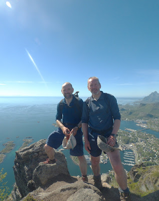
The following morning was bright and blue so we just had to scramble our way up Hellsegga (544m high) and take in the panorama.  


These hills aren’t that high but they are definitely steep. By 6pm we’d scrambled back down, struck camp, paddled another few hours and were having a coffee break on the decking at the Brygga restaurant in the harbour at A.


Had a rest day (day 12) from the sea by walking up Floya (590m) – this is the mountain behind Svolvaer the main town of the islands – and under deep blue skies got some great views across the area from the twin summits.  There was also the “Devil’s Bridge” rock to stand on with its significant fall exposure (good photo opportunity though).  Had dinner in a smart restaurant in town including cod’s tongue as a starter and various baked cod main courses.  Beer was £7.50 a pint.  Lovely sunny evening amongst the tourists.


On the south coast of Moskensoya we also paddle-explored the inland routes behind the coastal villages (Djupfjord, Kjerkfjord, Forsfjord etc) before heading north up the sound of Kakersundet and back to Ramsburg. 


There’s a number of pretty impressive bridges to see all round Lofoten that are “Skye Bridge” lookalikes; some of which need the right tidal direction to get under but never delayed us by more than about 90 mins.  Saw another sea eagle on this section but it was being mobbed by the Terns presumably to protect their nesting sites.  

Loop 1 was completed at a total of 279 kms in the boats and 3 hill walks.


Part 3 coming soon...